 Meet the magical Edge Lane Road!
A revolutionary design could help small towns build active transportation networks on a dime, only if it was better understood!
January 28, 2021
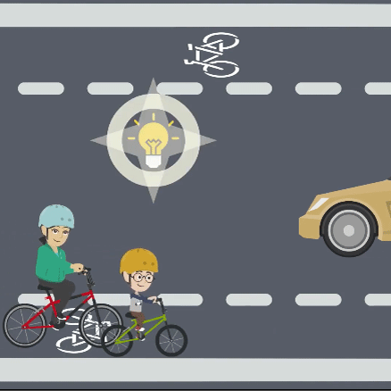
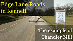
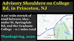
Edge Lane Roads or ELRs (also sometimes referred to as advisory bike lanes or advisory shoulders) are a type of roadway shared by drivers, cyclists, and pedestrians. Here is a short video summarizing the benefits of ELRs, showing how they work, and demonstrating what they might look like on Chandler Mill Road. To see the only ELR in our region, watch Margot and I cycle the recently installed advisory lanes in Princeton. While ELRs might not be suitable over long distances, they have proven to be a quick and cost-effective way to connect specific sections within a larger network. In fact, all you need for an ELR on most local roads is paint, signs, and public education!
We consider each of the benefits and each of the barriers associated with ELRs in greater detail below. While each benefit is encouraging, the cumulative impact is almost magical! We finish by commenting on why the human mind fails to appreciate these effects, by taking a page from the experience of the CoVid pandemic. That lesson? That the Swiss Cheese of many imperfect solutions can nonetheless offer a remarkable level of protection, from a rampant virus OR a distracted driver.
Many of these resources were drawn from Michael Williams' excellent website, and many of the insights were cemented through conversations with him over the course of this project. Any credit due rests squarely to Michael - all mistakes are mine!
These ideas are not intended to replace the advice of a trained engineer, but to help the general public understand why edge lane roads are so revolutionary, using the example of Chandler Mill Road (CMR). A traffic engineer experienced in ELRs is absolutely essential to their design and implementation.
The obvious benefits
- Drivers will no longer have to pull out to pass cyclists and pedestrians. Giving these trail users (sometimes referred to as vulnerable road users or VRUs) their own lane users is especially important. An accident only involving cars at 30mph is costly and inconvenient: not so for for trail users . For example. a study by AAA estimates the risk of serious injury to a pedestrian hit by a car increases from 25% at 23mph to 75% at 39mph.
- ELRs also accommodate pedestrians, though many ELRs were designed first with cyclists in mind. The very beautiful and very popular Gore Valley Trail in Vail illustrates this well, and includes sections that are ELRs (while also addressing sections with limited sight distance, described below).
- The impact on the environment is minimal. ELRs utilize the existing roadway... no need to cut down trees, intrude on the neighboring landscape, manage additional run-off, and all of the other environmental impacts associated with most other solutions.
- The costs are minimal relative to many other solutions. Once a road suited to an ELR has been identified, all you need is paint, signs, and public education.
Level of Traffic Stress (LTS) analyses show how ELRs can make shared roadways suitable for all users
LTS reveals how some ELRs can become almost as safe and as comfortable as a separate shared path... at a fraction of the cost!
Level of Traffic Stress or LTS is a commonly used framework to understand why - and how - different types of routes, roads, and intersections feel safe and comfortable for the different types of cyclist described below. Ideally, a route like the Kennett Greenway should try to accommodate all four types of cyclists - e.g., to be suitable for users of all ages and abilities, including LTS 1 and 2.
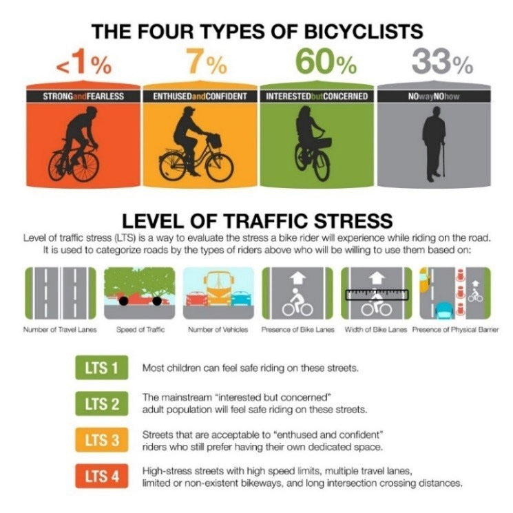
The type of roadway LTS is determined largely by characteristics of the roadway, like the amount of volume of traffic (expressed as Average Daily Traffic or ADT), the type of traffic (cars versus trucks) and the speed of traffic. These factors are all related to the type of roadway – whether it will primarily serve a small residential community, or is a road which others drivers might travel through. A local road like Chandler Mill that primarily serves a residential community would typically be considered an LTS 2 or even an LTS 1 road, depending most strongly upon the speed and volume of traffic. A traffic study can help to establish that!
The extra challenge of rural roads The curves and hills typical of rural roads can limit what drivers can see in front, and can challenge the safety and comfort of enthusiastic (and sometimes even more fearless) cyclists. So it is not surprising that ELRS on roads like Chandler Mill require measures to address those concerns.
Separating cars from other users Not surprisingly, trail users experience the least traffic stress on a separate path or, if that is not possible, when they are separated by a hard barrier like a curb or railing. Multiple reviewers also recognize, however, that even a lane separated only from car traffic with a line can be safe and comfortable for all trail users when traffic speed and volume is low enough. A traffic study capturing speed and volume can help determine whether a barrier s are needed on a local road like Chandler Mill.
Conclusion: ELRs can be appropriate for users of all ages and abilities. So taken together, LTS helps us to imagine how a road like Chandler Mill might become suitable for all trail users. Creating a low stress route with just paint, signs, and education, instead of a separate, multi-use trail at $1 to $4 million/mile... well that changes everything!
Using the science of curves and stopping distance to design ELRs that are safe and comfortable
The physics behind seeing an obstacle and stopping a car are well-known. So are the solutions
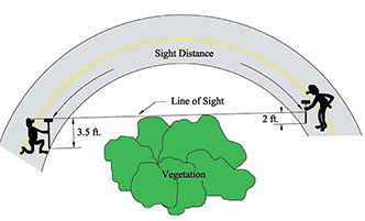
How far ahead must a driver be able to see in order to comfortably stop or pull around something they come across on the road, like a pedestrian or a cyclist on the shoulder? On most sections of most roads, drivers can see far enough ahead to comfortably pull around. But what happens when the line of sight is blocked by a curve, a hill, and or vegetation (see diagram to the right)? These questions become more important on roads like Chandler Mill that are also used by pedestrians and cyclists, but that might include sections with limited sight distance. Fortunately, the science of sight and stopping distance is very well-understand - it is a direct function of the driver's speed, reaction time/vigilance, and road conditions. It tends to be conservative, assuming that drivers are not immediately applying full pressure on their brakes.
ELRs effectively address this problem because cars no longer need to pull around trail users, who travel in their own lane. The fact that drivers on an ELR share a center travel lane creates, however, a somewhat different scenario for traffic engineers to address: how much room must two drivers approaching one another in the center travel lane need to be able to comfortably stop or pull around one anther on the shoulders, as they round a curve or crest a hill that might limit their sight distance? The science of sight and stopping distance in this scenario is described clearly by Williams (2020), drawing largely on the same principles described above. Williams estimates that the head-on stopping distance for two cars each traveling at 25 mph on an ELR is 230’ and for two cars traveling at 20 mph is 165’.
Fortunately, the solutions to these problems are also well understood
- Drop the driver’s speed. Dropping the overall speed limit on a road like Chandler Mill from 35 to 25 mph will eliminate all concerns as long as drivers can see at least 230' in front of them. You can decrease speed further for a specific section using signs (or other measures as described below); dropping from 25 to 20 mph will eliminate all concerns as long as drivers can see at least 165' in front of them,.
- Improve visibility, by removing brush or trees, shift the roadbed, or remove portions of a shoulder or a hill that obstruct the view.
- Revert briefly to two travel lanes, perhaps with a widened roadway, ideally with a wider shoulder to accommodate other users.
- Increase the driver's vigilance, discussed next!
Using traffic calming to control speed and increase vigilance
The psychology of speed and attention on an ELR combined with traffic calming just makes common sense!
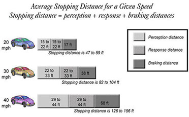
While the behavior of cars traveling at speed can be predicted by physics, the behavior of drivers cannot. An inattentive and/or speeding driver renders careful calculations of stopping distance irrelevant. Fortunately, the psychology of speed is also clear. Consider the earlier figure provided by the Florida Safety Council : the speed with which a driver perceives and reacts to an obstacle is the most significant determinant of total stopping distance. And we also know that a driver's cone of attention decreases as their speed increases, as illustrated to the right.
Psychology also provides solutions to slow the speed and improve the vigilance of drivers. Engineers refer to these effects as traffic calming. And here is where ELRs offer a surprising benefit: nothing seems more likely to increase vigilance AND decrease speed than the knowledge that you share the center travel lane with approaching traffic, much as one does when in a narrow alley or in a crowded parking lot. This powerful traffic calming effect of a shared travel lane could be reason enough to implement an ELR, even without the benefits of a designated travel lane for cyclists and pedestrians. The designated lanes for cyclists and pedestrians that bracket the center driving lane also serve as a constant reminder that more trail users are present, and seem likely to further increase a driver's vigilance.
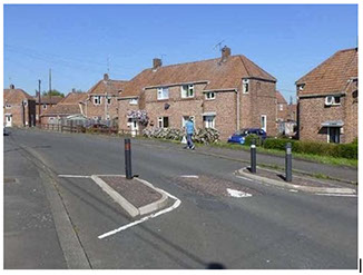 Traffic engineers have other, more traditional tools to calm traffic still further. Most notable are pinch or choke points, often some combination of curbs, posts, and other obstacles that briefly narrow the roadway, as in the example to the right. They can be as narrow as 7-9 feet, and automatically trigger the driver's natural tendency to slow down. They can also serve as a visual cue, capturing the driver’s attention to a change in traffic or the roadway.
Pinch points on an ELR are especially important on curves and hills that limit how far drivers can see in front of them. Not only do they provide drivers with an important visual cue but, when placed correctly, they can slow down drivers approaching curve or hill from both directions until they can see each other and can safely stop. Consider the example below, with a limited sight distance of 200' when vegetation blocks the drivers' field of view. When traveling at 25mph, drivers may be unable to see each other early enough to easily stop in time. But with the addition of the red rectangular pinch points, combined with signs slowing traffic to 20 or even 15mph, drivers slow down enough at the pinch to spot an oncoming car in time to stop. 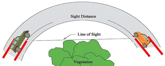
Other benefits
- Decrease vehicle roadway departures: Thirty people each day die from roadway departure crashes on rural roads, one-third of all traffic fatalities in the US. Narrow rural roads leave little room for error . A momentary lapse, and a driver drifts two feet to find themselves on a shoulder that might be soft or facing a tree that is very hard. An ELR's center travel lane with 5'shoulders on each side gives drivers more room to briefly err.
- Pavement life: Asphalt streets often fail either because if cracking at the edges which migrates to the rest of the street, or rutting caused by vehicles taking the same path over and over. ELRs move cars to the center of the road and away from the sensitive edge, reducing failure of the edge. They also cause drivers to take varying paths as they drive the road, reducing rutting.
- Cleaning: Once you've swept or snowplowed the road, the path is also done!
The final barrier: Educating users
Almost every account of a project introducing an ELR describes an initial stage of public concern, namely that users will be confused and that accidents will increase. But the data and outcomes tell a different story: no evidence of a increase in accidents, despite increases in the volume of trail users. Public education about what ELRs are, and how they work, is important in anticipating these concerns (and why we worked to assemble this information here!).
One way to demystify ELRs is to point out that many drivers - especially in rural regions with narrow roads - already find themselves often sharing a center travel lane. Every time we encounter a one lane bridge, or a road narrowed by a parked truck, we immediately drop our speed, increase our attention, and make a conscious decision about when and how to proceed. So drivers already know what to do on an ELR.
Implementing an ELR: Monitoring safety, compliance, and satisfaction
Data-based decision making to satisfy even the most skeptical!
Another way to address concerns about the safety and comfort of ELRs is to gather data on whether they are appropriately used, whether users are happy with them, and whether they are more likely to walk, bike, or drive on them. And the best? Basing future decisions on these data.
The safety of ELRs: Safety is often one of the primary concerns expressed by trail users, and especially those unfamiliar with shared roadways like ELRs, During the initial planning process, it is important to review the excellent safety of ELRs. A recent paper reviewed the safety performance of ELRs across the US during a three year period after they were first installed, relative to the safety performance of other similar roadways. These analyses reveal no overall increase in crashes, suggesting that the relative inexperience of drivers with ELRs did not make them less safe. The is consistent with anecdotal reports that, once drivers see an ELR in action, they recognize that they already engage in similar behaviors (i.e., navigating through a narrow alley, around parked cars, or in a crowded parking lot). In fact, these estimates suggest a 44% reduction in crashes, perhaps reflecting the positive impacts of driver attention and reductions in speed as described earlier.
Monitoring usage: Monitoring the actual usage of an ELR during and after installation is an excellent way to address questions and concerns. For Chandler Mill Road, for example, we proposed a plan that monitors usage as different sections of the roadway were transformed, from the easiest to the most difficult. This allows decisions to move ahead with the next phase to be data-based, potentially satisfying residents AND regulators alike. When monitoring usage, consider the following dimensions
- Compliance. What do you see if you film users? Do cars stay in the center lane when no other user is present? Do they pull into the edge lane to pass an oncoming vehicle, or to give more room to a cyclist or pedestrian? Do cyclists and pedestrians stay in their lane? With the guidance of a traffic engineer, cameras, and/or a team of volunteers, these kind of data can be gathered.
- Satisfaction. Are drivers, cyclists, and pedestrians happy with the ELR? There may be different levels of satisfaction across these three groups. Pedestrians and cyclists uncomfortable with how cars pull around them will be immediately satisfied; drivers inconvenienced by the lowered speed limit or anxious in the shared lane less so. And this might change over time, as users become more comfortable with the design. These trends are all evident in the data available elsewhere.
- Volume. Do more cyclists and pedestrians use the ELR than had used the road before its installation? A combination of increased volume AND user satisfaction is perhaps one of the best indicators of success. Decreased car traffic following the installation of an ELR lowers the risk of serious accidents even more. Again, these trends are all evident in the data available elsewhere.
What can CoVid teach us about ELRs? That Swiss Cheese may be stronger than concrete!
Early on in any initial conversations about ELR, someone will say something like "I cannot trust drivers, and will only consider walking in the roadway if I am protected from traffic". This concern is perfectly understandable, because most people who walk or bike regularly on the shoulder of a small rural road have stories of cars passing them too quickly or too closely. And so ensues a discussion about the only possible solution - some kind of hard barrier - a concrete curb, steel railing, or another barrier strong enough to stop a car hurtling at 40mph.
We are naturally drawn to that single perfect solution that will prevent problems with 100% reliability... But sometimes there is no silver bullet, or it is simply too expensive or too complex to implement. In the case of Chandler Mill Road, there is simply no room for a separate path, without seizing land, intruding into sensitive wetlands, etc.
We also find it difficult to recognize the cumulative effects of many small but imperfect solutions. Unless you are a numbers nerd intrigued by the science of probability, these calculations of multiple outcomes just seem too fuzzy to count on. How can many imperfect solutions yield one that is almost perfect? And so each imperfect solution is a inevitable disaster just around the corner, a speeding car hurtling around a curve towards you, probabilities be damned!
It turns out that our inability to fathom the cumulative impact of many imperfect solutions has deadly consequences, leading some to dismiss the many measures recommended to limit the spread of CoVid. This is the Swiss Cheese model, summarized eloquently in the New York Times. Each imperfect solution is like a slice of Swiss Cheese. As the probability of failure increases, the size of the hole in each slice increases. As you add more layers, especially those with smaller holes, the probability that these holes will all line up decreases, until it becomes virtually non-existent. In the case of CoVid, mask-wearing, hand-washing, social-distancing, avoiding indoor spaces, increased access to rapid testing, and so on are each imperfect solutions, but when combined they can dramatically decrease the likelihood that an individual will contract this potentially fatal disease.
The same model can explain the cumulative effects of ELRs combined with other strategies to significantly lower the probability of accidents. This is captured in a crudely modified of the Swiss Cheese model referenced above.
Reap the Benefits
Works for cyclists & pedestrians
Trail users have their own lane
Minimal environmental impact
Minimal cost
Suitable for all ages and abilities
Calms traffic with other measures
Can monitor compliance
Other benefits
Overcome the Barriers
Address sight and stopping distance
Educate users
Monitor Safety & Usage
Reap the Benefits
Works for cyclists AND pedestrians
Trail users have their own lane
Minimal environmental impact
Minimal cost
Suitable for all ages and abilities
Calms traffic with other measures
Other benefits
Overcome the Barriers
Address sight and stopping distance
Educate users
Monitor Safety & Usage
Reap the Benefits
Works for cyclists & pedestrians
Trail users have their own lane
Minimal environmental impact
Minimal cost
Suitable for all ages & abilities
Calms traffic with other measures
Other benefits
Overcome the Barriers
Address sight and stopping distance
Educate users
Monitor Safety & Usage
Reap the Benefits
Works for cyclists & pedestrians
Trail users have their own lane
Minimal environmental impact
Minimal cost
Suitable for all ages and abilities
Calms traffic with other measures
Other benefits
Overcome the Barriers
Address sight/stopping distance
Educate users
Monitor Safety & Usage
Reap the Benefits
Works for cyclists & pedestrians
Trail users have their own lane
Minimal environmental impact
Minimal cost
Suitable for all ages and abilities
Calms traffic together with other measures
Can monitor compliance
Other benefits
Overcome the Barriers
Address sight and stopping distance
Educate users
Monitor Safety & Usage
Reap the Benefits
Works for cyclists & pedestrians
Trail users have their own lane
Minimal environmental impact
Minimal cost
Suitable for all ages and abilities
Calms traffic with other measures
Other benefits
Overcome the Barriers
Address sight and stopping distance
Educate users
Monitor Safety & Usage
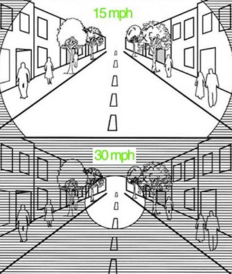
The cone of attention as function of speed

Considered individually, factors like the decreased driver speed and increased vigilance naturally resulting from an ELR seem imperfect. But when these are implemented with other measures (especially to address curves and hills with limited sight distance), on roads with already low volumes and accident rates, these dramatically decrease the likelihood of an accident until it becomes extremely unlikely.

