Hikers with ID
Matching each hiker with the right trails can help hiking planners and partners to find the perfect hike.
How can I find trails now?
A detailed inventory of hikes in our region reveals just how overwhelming the choices are for beginners
How are trails rated?
The criteria for rating trails of varying levels of difficulty are not that useful to beginning hikers with ID!
Access adventure
Using existing data to carefully cali- brate hikes that help beginning hikers grow over time into adventurous ones.
Building a trail inventory
Applying progressive access to the inventory of trails in our region reveals a wealth of great options.
Evidence-based practices
How can you adapt core EBPs identified for other skills and behaviors to hiking?
A community of hikers!
Imagine creating new social connections, and building a regional trail inventory together!
Coming soon
How can I find trails now?
How many trails appropriate for a beginning hiker are within an easy drive?? The answer will both surprise AND confound you!
March 20, 2020
Based on the characteristics of hikers with I/DD described , most of the accommodations relevant to the trail systems themselves rely on an awareness and understanding of the characteristics of existing trails in the region. As we shall see, this is especially true for beginner hikers, who may only need the kind of short smooth trails typically available in many local, state, and national parks. This is very important, because the development of new trails or the improvement of existing trails can be a long and costly process. Nonetheless, this depends on a thorough understanding of the relevant characteristics of trails, and on developing an inventory of short hikes in a given region.
Using existing apps: An Alltrails Regional Trail Inventory
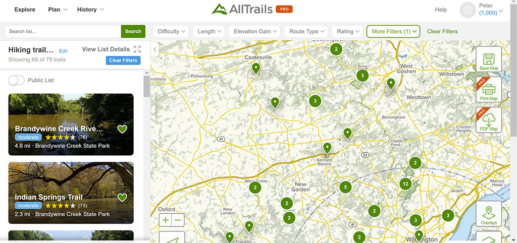
To test the usefulness of different possible criteria for a local trail system, we created a list on Alltrails of all hiking trails within a 30 minute drive of Kennett Square, Pennsylvania. We selected a 30 minute drive to make it more reasonable to aim for at least 1 to 2 short hikes per week.

We selected Alltrails because of the number of filters available, the number of trails listed, and the option to download GPX files that allow distance, elevation changes, and slope to be roughly calculated. Using Alltrails as a base also allows us to assess the extent to which commonly available apps and other web-based resources can be useful tools for beginners to plan their hikes. We recognize that other sources (e.g., other private websites, state and national park systems websites, and so on) may list other trails. We are therefore planning on surveying these other sites at a later point, to create a more complete sample for our own regional planning, to more fully assess the range of hikes than might be reasonably identified, and to illustrate the challenge for beginner hikers seeking to use currently available resources
Using these criteria, we found almost 80 trails listed in Alltrails within a 30 minute of Kennett Square PA. This assessment reveals a wealth of exciting options for hikers and hiking planners, while also illustrating a fundamental challenge: where to start. For example, the trails varied widely in length, with some less than 1 mile to others more than 10 miles.

Most (about two-thirds) were rated as easy using Alltrails system (which presents other problems, discussed later). The remainder were rated as moderate. In response to an inquiry regarding how trail difficulty is determined, Alltrails replied that "Difficulty ratings are based on distance, elevation and trail conditions ( rocks, obstacles, mud, etc). Trails with elevation gain over 500 feet are generally moderate and difficult trails.".
Other details were difficult to gather from the descriptions of the trails, even when these descriptions are available. For example, no information was available regarding the trail surface for about 1/3 of trails included. When descriptions were available, only about 20% were a paved or a hardened surface, and the rest were natural or mixed surfaces.
Design by Jeremy Goldberg
Muse-Themes.com
The logo is adapted from Joaquim Alves Gaspar's drawing of Pedro Reinel's compass rose.
Connect
Hikers with ID
Matching each hiker with the right trails can help hiking planners and partners to find the perfect hike.
How can I find trails now?
A detailed inventory of hikes in our region reveals just how overwhelming the choices are for beginners
How are trails rated?
The criteria for rating trails of varying levels of difficulty are not that useful to beginning hikers with ID!
Access adventure
Using existing data to carefully cali- brate hikes that help beginning hikers grow over time into adventurous ones.
Building a trail inventory
Applying progressive access to the inventory of trails in our region reveals a wealth of great options.
Evidence-based practices
How can you adapt core EBPs identified for other skills and behaviors to hiking?
A community of hikers!
Imagine creating new social connections, and building a regional trail inventory together!
Coming soon