Hikers with ID
Matching each hiker with the right trails can help hiking planners and partners to find the perfect hike.
How can I find trails now?
A detailed inventory of hikes in our region reveals just how overwhelming the choices are for beginners
How are trails rated?
The criteria for rating trails of varying levels of difficulty are not that useful to beginning hikers with ID!
Access adventure
Using existing data to carefully cali- brate hikes that help beginning hikers grow over time into adventurous ones.
Building a trail inventory
Applying progressive access to the inventory of trails in our region reveals a wealth of great options.
Evidence-based practices
How can you adapt core EBPs identified for other skills and behaviors to hiking?
A community of hikers!
Imagine creating new social connections, and building a regional trail inventory together!
Coming soon
Existing trail ratings systems
While the criteria and the costs of creating accessible trails are very well understood, the criteria and costs for creating more difficult kinds of trails are much less certain.
March 20, 2020
Traditional standards for accessibility
 Standards for ensuring handicap access for people with significant physical disabilities or who are deaf or blind are well-established in the United States. In state and national parks, these standards are captured in guidelines established by the United States Forest Service. The Forest Service Trail Accessibility Guidelines (FSTAG) set standards for the trails themselves (FSTAG, 2013). These are separate from a parallel but more stringent set of guidelines for ensuring access to recreational facilities in parks; the Forest Service Outdoor Recreation Accessibility Guidelines (FSORAG).

Forest Service Trail Accessibility Guidelines
Difficulty Standards for Hiking Trails
Easy More Most
Difficult Difficult
Firmness
Clearing Width
Tread slope
Running
- Average
- Maximum
Cross
Obstacles
Hardened
>36"'
<1:20
<1:12
<1:20
<2"
May be hardened Native surface Native surface
>48" 36-48" <36"
<1:20 <1:8 <1:6
<1:5, to 100' <1:3.33, to 300' <1:3.33, to 500'
<1:33 <1:20 <1:12
Generally clear <10" <24"
A number of organizations have used these guidelines to design new or modify existing trails to be accessible. The Pennsylvania Land Trust Association used these guidelines to develop a broader set of recommendations for sustainable and accessible trails (Pennsylvania Land Trust Association, 2014). The Appalachian Trail Conservancy described several examples of trail upgrades that utilized these standards (Appalachian Trail Conservancy, 2007). Recent efforts in our immediate region to increase accessibility include the redesign of trails in Brandywine Creek State Park and White Clay Creek State Park.
Critical trail features
The features used by FSTAG to establish that a trail as accessible are summarized here. Many of these are also incorporated into other rating systems described below, and the Progressive Access rating system we propose later.
Length
The length of a trail from start of finish. Some trail features are evaluated across the entire length of a trail, whereas others might be evaluated for a defined segment or section of a trail. The specific FSTAG standards for each of these dimensions are summarized in Figure 1 below.
Firmness
FSTAG requires that a surface be both firm and stable. This is accomplished by either using pavement, or a packed stone dust mixture that provides the same hardness.
Trail width
FSTAG specifies the minimum width of a trail, in several places. The Tread Width refers to the surface area where a hiker will step. The Clearing Width is the width of the trail at about shoulder height. The Passing Space establishes the width required to allow two users to pass one another.
Slope
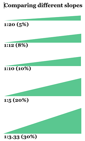
The slope is the distance traveled for every one foot increase in elevation. For example, a 1:20 slope means that you experience a one foot increase in elevation for 20 feet of trail. This can also be expressed as grade (in this example, a 5% grade). A typical staircase is around 1:3. You can see what this looks like in the diagram to the right.
- Running Slope is calculated in the direction of travel. It can be expressed as an average or a maximum across an entire trail or trail segment. It can also be expressed as n average or a maximum across a subsection of a segment (e.g., no more than a 1:10 slope for a maximum of 200 feet). FSTAG specifies the maximum running slope across the entire trail, and the maximum slope of a specified length of trail.
- Cross Slope is calculated perpendicular to the direction of travel (i.e., side to side across the trail width). FSTAG specifies the maximum cross slope across the entire trail.
Other features
Obstacles refer to anything that might protrude from the surface of a trail and that trip a hiker up. FSTAG specifies the maximum height of obstacles at any point across the trail.
It is also worth noting that FSTAG specifies that Signage posted for any accessible trail includes some of the information listed above, as well as the date when the trail was constructed or last assessed.

The limitations of accessible trails
Relying solely on trails that meet FSTAG standards will, however, become quickly problematic for the new hiker. FSTAG standards do not establish different levels of accessibility; consistent with the spirit of other ADA standards, a trail is either accessible or it is not. While an accessible trail is guaranteed to minimize obstacles to a beginning hiker, the only option for hikers seeking a greater challenge will be to increase the length of the hike. The stringent standards established by FSTAG also makes accessible trails expensive to design, and even more expensive to build. In many cases, trails that meet such standards are simply impracticable because of the terrain.
Truly accessible rails are therefore relatively rare, especially as trails of increasing length or variety are sought. For example, the 2 mile, fully accessible Gregg Trail rises a total of 200 feet to an overlook at Crotched Mountain in New Hampshire, but remains one of the few such trails in a mountainous environment. While 6 of the 79 trails in our sample were listed as wheelchair accessible, this simply indicates that the trail meets standards with respect to firmness, tread width, and tread obstacles. These ratings do not necessarily address FSTAG standards with respect to slope. The percentage of trails that meet all FSTAG standards is therefore likely to be very small, and would severely limit the options available to new hikers in any given region.
Other trail rating systems
Other trail rating systems intended to provide some overall measure of difficulty generally reference some of all of the same dimensions as FSTAG. Typical of these are the Difficulty Standards for Hiking Trails, used in Pennsylvania State Parks (Pennsylvania Department of Conservation and Natural Resources, 2017), and elsewhere. These are compared to the FSTAG standards above in Figure 1. The Trail Rating system for the International Mountain Biking Association rely on a similar set of dimensions. Other systems, like those adopted by Alltrails, rely on informal user ratings that often reference distance, elevation and trail conditions (rocks, obstacles, mud, etc) even more loosely.
A key difference is that many of these other trail rating systems not only rate the whole trail, but they factor the length of a trail into the calculations of its difficulty. In contrast, hikers, planners, and partners will find it helpful to consider the length of a hike independently from its other features. It may not always be easy to predict which other features (like the effort of ascending a steeper section, or the challenge of navigating obstacles on the trail) might alone or together make a hiker uncomfortable. The rating systems that factor the length of a trail into the overall difficulty rating do not give hiking planners and partners the capacity to evaluating each of these factors independently, which might be especially important for beginning hikers.
It is also worth remembering that FSTAG standards are sometimes applied to sections or segments of a trail rather than a whole trail. This simply recognizes that conditions can sometimes vary from one section of a trail to another, and that a rating based on an entire trail may mask a segment of the trail that is accessible. Ratings based solely on the entire trail do not provide the options for a hiking planner to assess the difficulty of a shorter segment. This may sometimes lead to an underestimation of the number of easy trail segments in a region, especially in states like Pennsylvania that recommend developing trail systems in which more than two-thirds of trails are rated as more or most difficult (PA DCNR, 2008).
Gathering and using data on trail characteristics
One benefit of the FSTAG standards is that these require that trails are carefully designed, and so hiking planners can therefore feel very confident that a trail described as accessible designated trails meet the standards described. For all other trails, however, there is not only no guarantee that the trail meets the standards outlined, but no way for planners to easily gather these data elsewehre to make thei own determination. While GPX data available through sites like Alltrails can help roughly estimate large changes in running slope across different sections of a hike, more detailed data on trail obstacles and trail width are rarely provided. Gathering such data using traditional mechanisms can be costly and time-consuming.
It also seems likely that planners may struggle to make sense of these data, even when these are available. Consider other efforts to provide trails and trail ratings systems that are more tailored to this population. One company - Beneficial Designs - has developed a suite of services that includes sophisticated trail mapping equipment paired with alternative maps and signage that conveys to hiking planners detailed data regarding critical FSTAG dimensions, like running/cross slope, trail width, and so on (click on the sample to the right for more information). It remains unclear, however, the extent to which hiking planners need - or can effectively use - data this detailed, and the trail mapping equipment required can be costly.
Our solution to many of the issues raised above is described next. Progressive access extends existing standards to capture increasing levels of difficulty in ways that are meaningful and useful to hikers, hiking partners, and hiking planners, especially for those beginning to hike and working on assembling a regional inventory of trails.
Previous
Next
How can I find trails now?
How many trails appropriate for a beginning hiker are within an easy drive? A detailed inventory of hikes in our own region reveals just how overwhelming these choices are for beginner hikers.
Our Solution: Progressive access
Progressive access uses data to guide planners in selecting regular 60 minute hikes that are calibrated to gradually build the capabilities of hikers to take on more and more challenging trails.
Design by Jeremy Goldberg
Muse-Themes.com
The logo is adapted from Joaquim Alves Gaspar's drawing of Pedro Reinel's compass rose.
Connect
Hikers with ID
Matching each hiker with the right trails can help hiking planners and partners to find the perfect hike.
How can I find trails now?
A detailed inventory of hikes in our region reveals just how overwhelming the choices are for beginners
How are trails rated?
The criteria for rating trails of varying levels of difficulty are not that useful to beginning hikers with ID!
Access adventure
Using existing data to carefully cali- brate hikes that help beginning hikers grow over time into adventurous ones.
Building a trail inventory
Applying progressive access to the inventory of trails in our region reveals a wealth of great options.
Evidence-based practices
How can you adapt core EBPs identified for other skills and behaviors to hiking?
A community of hikers!
Imagine creating new social connections, and building a regional trail inventory together!
Coming soon

