Hikers with ID
Matching each hiker with the right trails can help hiking planners and partners to find the perfect hike.
How can I find trails now?
A detailed inventory of hikes in our region reveals just how overwhelming the choices are for beginners
How are trails rated?
The criteria for rating trails of varying levels of difficulty are not that useful to beginning hikers with ID!
Access adventure
Using existing data to carefully cali- brate hikes that help beginning hikers grow over time into adventurous ones.
Building a trail inventory
Applying progressive access to the inventory of trails in our region reveals a wealth of great options.
Evidence-based practices
How can you adapt core EBPs identified for other skills and behaviors to hiking?
A community of hikers!
Imagine creating new social connections, and building a regional trail inventory together!
Coming soon
The adventurous hiker
Progressive access adds other layers of information helpful to hiking planners and partners for hikers ready for even greater challenges.
June 23, 2020
 So you and your hiker can complete at least a 1 1/2 mile hike on natural trails under a range of weather conditions. You now have established routines for checking in with your hiker while monitoring your progress on a map, and taking breaks as needed. So what's next? Maybe nothing at all, if you have established a weekly routine and a repertoire of hikes that meets your hiker's needs.
But maybe now you want something more? For example, maybe you want to go even further on your hikes. Some of the trails on the curated list may offer this option. But what if you want to look for hikes outside of this list? The only reliable options here are paved paths and rail trails. Calculating the effort require by a paved path or rail trail is easy, because this is largely determined by the length. Aside from some gentle slopes, these options do not present any of the features that can make trails become significantly more difficult: they rarely have steep sections, and are always even and wide.
But maybe you have learned to love the sights and smells of a meadow trail, or the solace of a forested path married with the sounds of a quiet stream? In this case, you will want something different from most rail trails, something that begins to resemble a more traditional hiking trail. Many of the more traditional hiking trails present steeper slopes and more varied surfaces that your hiker has yet to experience. Assessing the effort required for trails with more varied widths and surfaces presents new challenges for those curating an inventory of trails. These details are not available from available data, because they require that coordinators walk each trail to evaluate it, or bring in others to do so. Without this information, hikers and their partners can quickly find themselves on a trail they are not prepared for.
And maybe you want to begin exploring hikes outside of the curated list for your region? For example, maybe you want to make hiking part of your vacation or a summer roadtrip, to break up your drive or to give you more options for things to do once you reach your destination. The bad news is that, as discussed previously, traditional trail rating systems rarely offer the kind or the level of detail you need to plan a successful hike. As you look at other trails, how do you guess-timate whether these are beyond the reach of your hiker? The good news is that you have already helped your hiker to develop a capacity for longer hikes on natural trails, and have some room for under-estimating the effort required. But poorly documented trails can become really difficult really fast.
Fortunately, there are solutions for the more adventurous hiker. You can begin by using a curated inventory to practice on progressively more difficult trails in your region. And then, you can begin to identify parks and preserves that offer a range of natural trails, and experiment with reading trail maps and creating routines to try out trails that test you with unexpected challenges.
Building towards adventure using curated trails
Steeper slopes
Our beginner hikers explored trails with steeper sections ranging from 300 feet to up to half a mile, though only on paved trails. Most paved trails are relatively flat, limiting the opportunities to assess how our hiker copes with anything more than a gentle slope. Our adventurous hikers begin to explore natural trails, which can have much steeper slopes.
Comparing the different slopes in the diagram to the right is helpful. A 5 to 8% slope over a 300 foot section, or even a half mile, may be barely noticeable to most hikers. Some of our hikers will begin to feel the pace and may slow down or show other behaviors that signal that they are working harder. This becomes even more likely when these slopes are combined with changes in trail surface or width, as discussed below. But even a typical, experienced hiker will begin to feel a 20-30% slope.
Trail surfaces and obstacles
Many natural trails have sections with uneven surfaces. The increased erosion of steeper trails (especially those that are poorly designed) will make natural trails uneven, with steeper slopes exposing even larger rocks and roots to create a more uneven surface. To classify a section of trail as mildly or moderately uneven, only 25% - or one out of every four steps - of a 1/2 mile segment need fit the criteria outlined below.
We would define an uneven surface as one with rocks or roots that protrude 1.5 to 2 inches above the trail surface. Mildly uneven surfaces are barely noticeable to typical hikers, who have the strength and balance to adapt immediately should they step on a small stone or root, or who will naturally glance down at the trail and step 6 inches to the side to avoid it. They easily adjust their rhythm and maintain their pace.
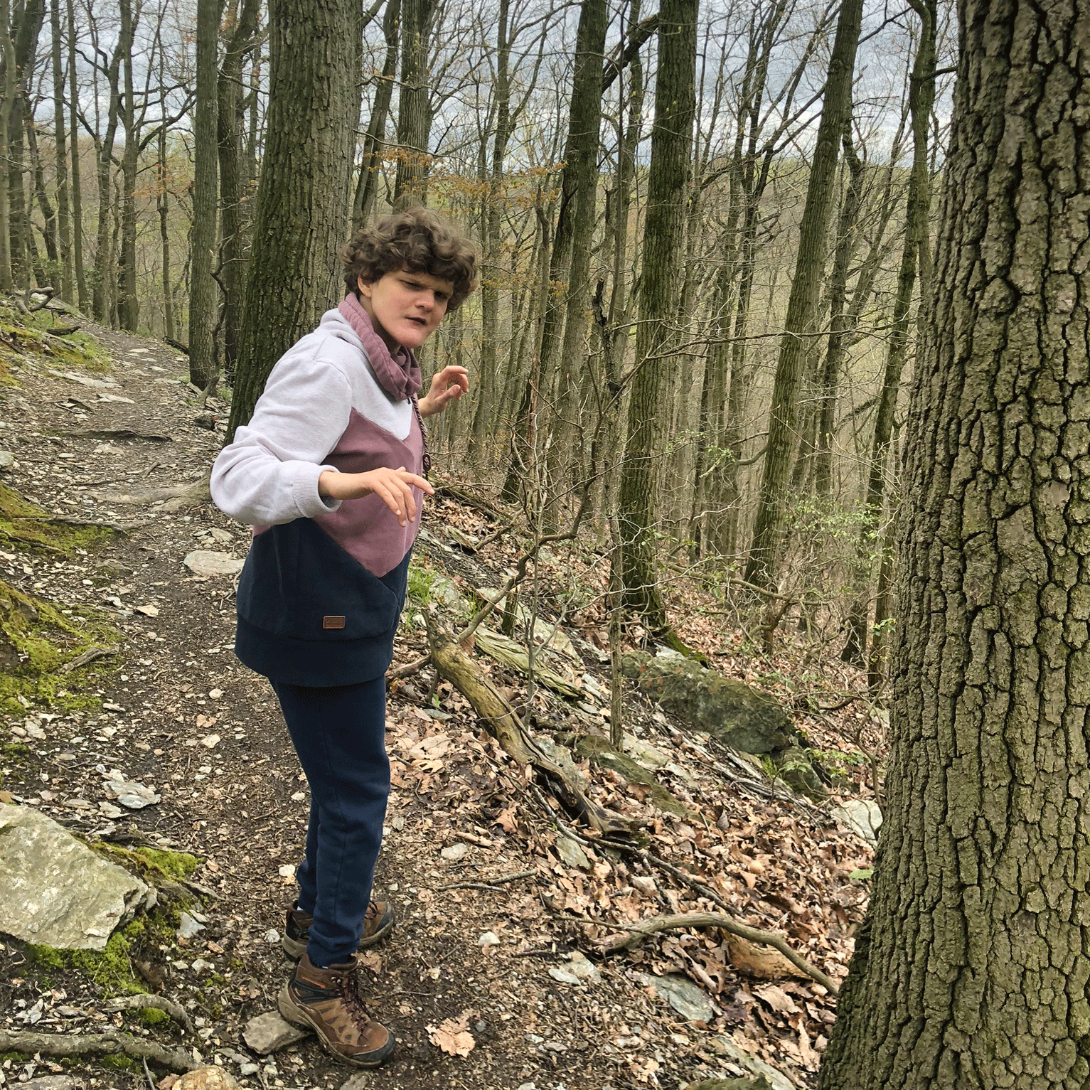
Our hikers are much more likely to notice even a mildly uneven surface. They might not monitor where they are stepping, or find it more difficult to adjust their step mid-stride. Hikers with poor balance and/or strength might twist their foot and trip. This can throw off their rhythm, and make them hesitate with each step. Their experience is akin to a cross-country runner moving at pace: a mildly uneven surface will disrupt their rhythm, making them either slow down or risk a trip, fall, or even twist (like Margot in the clip at the top of this page).
A minor 0bstacle is anything that a hiker has to step more carefully around: rocks and roots 2-12" high, sections with shoe-deep mud, low branches to duck under, etc. Even experienced hikers will have to slow down and step carefully around these kind of rocks and roots. Our hikers may have to take even more time. While they may enjoy the challenge of a careful step here and there, they might soon tire of this kind of adventure. As illustrated above, Margot knows to duck under a branch, she needs extra help walking over logs.
Major obstacles can be a much more significant problem, and may sometimes render a section of trail impassible. For example, Margot has yet to master stepping on rocks or logs to cross a small stream - even with help. And because I now know that she REALLY hates to walk in wet shoes, I have no choice but to turn back when I run into a stream. I now try to scan maps and trail descriptions more carefully for stream crossings, and hope to help Margot to navigate these obstacles, but for the moment, asking her to cross a stream is just too much... a bridge too far!!
Narrow trails
 Very narrow trail at Harmony HillBeginner hikers enjoy trails that are at least 5' wide, and often wider. This makes it easy to lean on a partner's arm for support (and encouragement), and pass (or be passed by) other hikers without breaking stride. Except for mowed paths through meadows, most natural trails are narrower. Many hikers may enjoy these narrower trails even more; winding through a close forest path seems to bring you even closer to nature. But narrower trails can create some unexpected challenges for our hikers.
Narrow trails These trails are 3-4' wide measured at the base, and require that hikers either walk without a partner by their side, or have to tolerate a partner squeezed in tight next to them. This poses few problems for hikers who are comfortable walking independently. Hikers who are less certain of their footing, however, may find a narrow trail to be harder, and may tend to slow down. All hikers have to be comfortable stepping aside to pass other hikers.
Very narrow trails Those trails are less that 3' wide measured at the base, and present even greater challenges. Hikers must be comfortable walking on their own, although a partner can sometimes prompt or support them from behind as needed. Very narrow trails can also require that hikers place each step more carefully, increasing their overall effort and slowing down their progress.
Combined challenges
Trails that combine challenges - steeper sections, uneven surfaces, minor and major obstacles, and trails that are narrow or very narrow - are very common. In fact, you should assume that most natural, forested trails in a nature preserve or state park combine some of these challenges, even some of those trails rated as easy. As seen on the video at the top of the page, even a gently sloped descent combined with an uneven surface is difficult for Margot to manage comfortably on her own. This increases the effort by a factor of 3 or even 4 for a hiker like Margot, relative to the effort required to hike a flat trail of comparable length.
Uncharted adventures
So now you want to look beyond a curated list of trails. Maybe you seek to discover, like the great Meriwether Lewis and William Clark, "as handsome a place as I ever saw in an uncultivated state". Or maybe you want to push your own limits, like those other iconic explorers, Star Trek's James T. Kirk and Jean-Luc Picard, to "boldly go where no one has gone before". Or maybe you are just being pragmatic, like the more ironic explorer Chevy Chase, desperate to salvage a long roadtrip on a Family Vacation: "This is no longer a vacation. It's a quest. It's a quest for fun. You're gonna have fun, and I'm gonna have fun".
 Cruising on Boulevard!Whether you are inspired by Lewis, Kirk, or Chase, how do you plan an uncharted adventure with your hiker? What you actually need to do is to boldly go where many have gone before (and left detailed maps and reviews)! You have to gather as much information as you can about about the trail characteristics, and then understand your options for taking a short cut if the trail turns out to be more difficult than expected. The biggest challenge when we began is that many trails are quite a bit longer than any Margot had attempted up to that point. Combine this with the lack of information on trail features, and you have a recipe for a long and less than pleasant hike.
To illustrate, consider a recent search...
- I started by reviewing what Margot is capable of. At this point, Margot's most difficult hike was on the Harmony Hill South Loop, a natural trail 2.7 miles long that was narrow, uneven, and slightly inclined (5-8%) for at least 1/2 of its length.
- I searched Alltrails for hikes less than 3 miles long, filtering out difficult trails, and looking for those with many positive reviews.
- Then I looked for any flags in the trail descriptions that could be encouraging (easy flat trail for kids) or not (examples of major obstacles).
- I scanned the list of potential trails to find one in a state/national park. These parks are more likely to include a detailed map (with mileage for trail segments and/or contour lines) and offer other trail options.
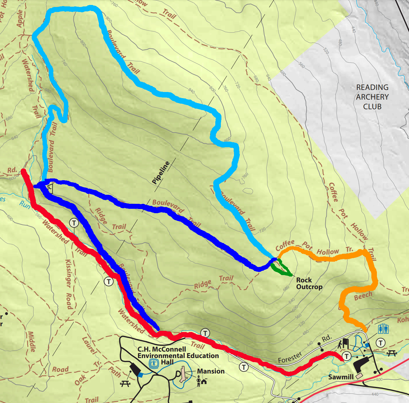
I settled on two options in Nolde Forest State Park (see map to the right). Alltrails listed the Watershed and Boulevard Trails (2.4 miles), with a very steady 5-8% incline for the first half. Reviews suggested that trail conditions were variable, which made me hesitate. The total length approached Margot's limit, and I was still not absolutely sure of other conditions that might make a hike difficult. But the Boulevard Trail to Watershed Trail Loop was only 1.5 miles long. Though rated as moderate, it is described as including a slightly inclined gravel road, and looked like a very steady 5-8% incline for the first half. This gave me the option of deciding at the half-way point whether to chose the shorter 1.5 mile option (red then dark blue then orange), or to attempt a 2.4 mile trail (red then light blue then orange).
Then there is what you try to plan for, and what you actually experience! The first time, I walked up Watershed, I cut over onto Boulevard because I wanted to save Margot's energy for a possible 2.4 mile hike. But I actually turned right to continue southeast on the shorter leg of Boulevard instead of continuing north onto the longer leg of Boulevard that I originally intended to complete. That turned out to be a good thing, as the Coffee Pot section at the end was unexpectedly difficult for Margot, a narrow and uneven trail with steep declines and occasional major obstacles that left her grinding her teeth. Fortunately, it was not too long, and ended with us arriving back at the parking lot. The second time I hiked at Nolde, we continued all the way up Watershed (which was definitely more difficult for Margot), and continued back along the route we took the first time. So maybe the next time, we will take Boulevard the whole way, continuing on to the longer leg.
Comparing Different Slopes
![]() 0 0
0 0
![]() .5 1
.5 1
 .5 2
.5 2
 2 3
2 3
 3 3
3 3
Increased effort score for any 300" section with a half mile segment, or as an average across a half mile
Add 1 point to the Effort Score when at least 25% of a section (1 of every 4 steps) has an uneven surface. Add 2 points when obstacles occur frequently (e.g. must be stepped around 1 of every 10 steps).
Add 1 point to the Effort Score for a given 1/2 mile section when more than 1/2 is narrow (3-4'), and 2 points more than 1/2 is very narrow (less than 3').

Nolde State Forest
Hover over to enlarge
Watershed natural, 8% incline, uneven, sometimes narrow
Boulevard (short) - hardened, wide, relatively flat
Boulevard (longer) ??
Coffee Pot natural, steep decline, uneven, very narrow

Next
Evidenced-based practices for hikers
Core EBPs identified as effective for teaching other skills or preventing problems in people with ASD can be readily adapted to building hiking skills and endurance for those with ID.
Coming soon
Design by Jeremy Goldberg
Muse-Themes.com
The logo is adapted from Joaquim Alves Gaspar's drawing of Pedro Reinel's compass rose.
Connect
Hikers with ID
Matching each hiker with the right trails can help hiking planners and partners to find the perfect hike.
How can I find trails now?
A detailed inventory of hikes in our region reveals just how overwhelming the choices are for beginners
How are trails rated?
The criteria for rating trails of varying levels of difficulty are not that useful to beginning hikers with ID!
Access adventure
Using existing data to carefully cali- brate hikes that help beginning hikers grow over time into adventurous ones.
Building a trail inventory
Applying progressive access to the inventory of trails in our region reveals a wealth of great options.
Evidence-based practices
How can you adapt core EBPs identified for other skills and behaviors to hiking?
A community of hikers!
Imagine creating new social connections, and building a regional trail inventory together!
Coming soon
